Inn Valley Target Area
TEAMx – Activities in the Inn Valley Target Area (IVTA)
Target Area representative: Manuela Lehner, University of Innsbruck
Last updated: 20 October 2023
Permanent infrastructure operated during the TEAMx Observational Campaign
i-Box [1]
Seven eddy-covariance stations, each instrumented with a 3D sonic anemometer and infrared gas analyzer at least at one height, are operated by the University of Innsbruck about 20 km east of Innsbruck. The locations cover different topographic (valley floor, mountain top, north- and south-facing sidewalls, steep and moderate slopes) and different land-use (grassland, agricultural, dwarf pine) characteristics. Six of the stations are full surface-energy balance stations with four-component radiation and ground heat flux measurements.
Innsbruck Atmospheric Observatory (IAO)[2]
A tower on the rooftop of an approximately 35-m high university building near the center of Innsbruck is instrumented with multiple 3d anemometers for turbulence and trace gas profiles. The top inlet is equipped for sampling a number of atmospheric gases and aerosols (e.g., NMVOC, NOx, O3, CH4, CO2, CO, UFP and PM1). Some of the measurements can be extended into the urban street canyon along a profile of sonic anemometers. Surface observations are complemented by a Doppler wind lidar and a temperature and humidity profiler operated on the rooftop to provide continuous vertical profiles of wind, temperature, and humidity.
Automatic weather station networks
Weather stations in the IVTA are operated by the Austrian national weather service (GeoSphere Austria[3]), the German national weather service (Deutscher Wetterdienst, DWD[4]) in the valley exit region, the avalanche warning service of the state of Tyrol (Lawinenwarndienst Tirol[5]), and the hydrological service of the state of Tyrol (Hydrographischer Dienst Tirol7), with more than 150 stations in total.
Ceilometer networks
The Austrian air traffic control agency Austro Control and GeoSphere Autria operate in total four ceilometers in the IVTA, three of them in the vicinity of Innsbruck..
Weather radar
Austro Control operates a dual-polarisation Doppler C-band radar at Patscherkofel.
FAIR (Forest-Atmosphere-Interaction-Research) site [6]
Operated by the University of Innsbruck and located about 30 km west of Innsbruck in a forest dominated by 12-m tall Scots pine (*Pinus sylvstris*), the site includes among others vertical profiles of 3D sonic anemometers, gas analyzers, and temperature and humidity sensors on a 30-m high tower; a 2-m high tower providing the surface-energy balance components and CO2 fluxes in the understory; and a walk-up tower to access the tree crowns. In total, over 100 sensors are operated continuously, measuring over 150 variables.
TEAMx Observational Campaign (TOC)
TOC Backbone
The surface-based remote sensing and radiosonde launch sites of the TOC
Backbone in the IVTA are shown in Figure 1. As the planning for the TOC
progresses, site locations may change slightly and additional sites may
be added. The goal is to monitor the vertical structure of the valley
atmosphere at different locations along the valley. To this end, Doppler
wind lidars will be operated at Kufstein near the valley exit by
GeoSphere Austria, at Radfeld by Meteo Swiss, at Kolsass by the
University of Innsbruck, and at Innsbruck by KIT/IMK-IFU. At Innsbruck,
radiosoundings are launched operationally at the airport once per day by
Austro Control. During the summer EOP, an additional Doppler wind lidar
will be operated at Brannenburg downstream of the valley exit by DWD and
two lidars towards the end of the Weer Valley, a small tributary valley
of the Inn Valley, by DLR. Vertical temperature and humidity profiles
will be measured using a Raman Lidar and a microwave profiler at
Innsbruck and Kolsass, respectively.
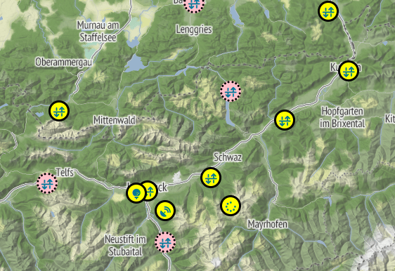 Figure 1: Surface-based remote sensing and radiosonde launch sites of
the TOC Backbone in the IVTA. Pink markers indicate locations that are
considered important, but for which instrumentation has not been secured
yet.
Figure 1: Surface-based remote sensing and radiosonde launch sites of
the TOC Backbone in the IVTA. Pink markers indicate locations that are
considered important, but for which instrumentation has not been secured
yet.
Airborne observations
Aircraft flights are planned with the TU Braunschweig Cessna to characterize the spatial structure of the Inn Valley atmosphere. Contact: Ivana Stiperski, University of Innsbruck
Supersite Hochhäuser (winter EOP)
The University of Grenoble and the University of Innsbruck will be deploying multiple instruments on a steep north-facing slope to study katabatic flows, turbulence in katabatic flows, advection, and local flow heterogeneity. The slope is characterized by a relatively homogeneous and approximately 400-m long stretch of Alpine meadow, with a line of trees to either side of the slope at a distance of about 70 m and a forest starting about 250 m up the slope. One of the i-Box stations has been operational since 2013 at the site. Instrumentation will be expanded with up to 10 automatic weather stations, multiple surface-energy balance stations including up to 9 sonic anemometers and a Pitot tube, and a distributed temperature sensing system. Contacts: Christophe Brun, Université Grenoble Alpes and Manuela Lehner, University of Innsbruck.
Supersite Kolsass (summer EOP)
The University of Innsbruck will be operating a network of up to 10 automatic weather stations, multiple surface-energy balance stations, and microbarographs in the vicinity of the i-Box station Kolsass, which will also host a Doppler wind lidar and a temperature/humidity profiler throughout the TOC (see TOC backbone). Instruments will be deployed up-valley, down-valley, and in the cross-valley direction from the 17-m high i-Box mast, where measurements are collected semi-operationally at three vertical levels. The goal is to study the surface-energy balance closure, advection, turbulence characteristics, and spatial heterogeneity. Contact: Manuela Lehner, University of Innsbruck.
Supersite Nafingalm (summer EOP)
DLR and the University of Innsbruck will be deploying two Doppler wind lidars, a surface-energy balance station, 10 automatic weather stations, and several temperature sensors in the upper part of the Weer Valley (Nafingalm), a small tributary valley of the Inn Valley. Additional measurements will be conducted with a swarm of UAVs to study slope and valley winds in this small valley, their interactions, and the impact of larger-scale circulations. Contacts: Norman Wildmann, DLR and Alexander Gohm, University of Innsbruck
Pre-campaigns (preliminary field campaigns and tests in the IVTA)
Pre-Campaign Summer 2022 (PC22):
took place in summer 2022, with measurement sites at Kolsass and surroundings, in the Weer Valley (Nafingalm), in Innsbruck, and the exit of the Inn Valley near Kufstein and Brannenburg. PC22 included contributions from KIT/IMK-TRO, DLR, DWD, GeoSphere Austria, and the University of Innsbruck. The goals were mainly to test (new) instruments and measurement sites for the TOC. Activities included lidar observations of the vertical wind structure at four different locations along the valley; scanning lidar observations of the nocturnal outflow from the Weer Valley into the Inn Valley; a lidar intercomparison study, distributed temperature sensing measurements; observations of the valley atmosphere in a small tributary valley using UAS, AWS, and temperature/humidity sensors; testing of a new Raman lidar and deployment of a co-located Doppler lidar; and detailed observations of the valley exit jet using multiple surface stations, a wind lidar, and radiosoundings. An overview of the measurement campaign and first results can be found in Pfister et al. (2023)[7]. Contacts: Lena Pfister and Alexander Gohm, University of Innsbruck
Pre-Campaign 2023 – Nafingalm:
Test measurements with a Doppler wind lidar and a UAV were conducted by the University of Innsbruck for three days in summer 2023 at Nafingalm in the Weer Valley to test for example the lidar range. Contact: Alexander Gohm, University of Innsbruck
Pre-Campaign 2023 – Kolsass:
A HATS[8]-type setup will be realized at the i-Box station Kolsass in autumn 2023 (Mountain HATS, MoHATS) by the University of Innsbruck. Two rows of four sonic anemometers will be deployed to capture horizontal and vertical flux divergences. In addition, automatic weather stations will be set up at short distances from the main site to quantify along-valley variability. Contacts: Ivana Stiperski and Manuela Lehner, University of Innsbruck
Pre-Campaign 2024 – Hochhäuser:
The University of Grenoble and the University of Innsbruck will conduct a test campaign at the beginning of 2024 to test the measurement setup on the steep north-facing slope for the TOC winter EOP. Contacts: Ivana Stiperski and Manuela Lehner, University of Innsbruck\
Pre-Campaign 2024 – Nafingalm
A four-week long test campaign is planned by DLR for summer 2024 to test lidar performance and UAV flights at Nafingalm for the TOC summer EOP. Contact: Norman Wildmann, DLR
Modeling activities
Model intercomparison study – Thermally driven flows:
A subgroup of the MoBL WG is performing an intercomparison of mesoscale models for a case study of thermally driven flows in the Inn Valley selected from the CROSSINN[9] field campaign to evaluate the model skill in different phases of the diurnal evolution of the convective mountain boundary layer (MoBL). The participating models include ICON, AROME, WRF, and GRAMM-SCI. Contact: Lorenzo Giovannini, University of Trento
Model intercomparison study – Cold-air pools:
A subgroup of the MoBL WG is performing an intercomparison of mesoscale models for a case study of cold-air pool formation in the Inn Valley selected from the PIANO[10] field campaign to evaluate the model skill in reproducing the cold-air pool strength, depth, and spatial extent. The participating models include ICON, MESO-NH, UM, WRF, and AROME. Contact: Manuela Lehner, University of Innsbruck
Model cases studies - Thermally driven flows:
Several case studies at kilometer and hectometer resolution are performed within Master’s theses at the University of Innsbruck to study the impact of model resolution, boundary layer parameterization, land cover, and tributary valleys on the representation of MoBL processes. Contacts: Alexander Gohm and Manuela Lehner, University of Innsbruck
Simulations of valley exit jets:
High-resolution PALM simulations will be performed by DWD for the Inn Valley exit region. Model output will be evaluated using observational data from the PC22 pre-campaign and used to study the characteristics and mechanisms of valley exit jets. Contact: Meinolf Kossmann, DWD
Model evaluation over mountainous terrain:
As part of the ASTER project[11] (University of Innsbruck, University of Trento, University of Bolzano) WRF simulations with a grid spacing of 1 km are performed for the Inn Valley to evaluate the impact of the land-use data set, boundary-layer parameterizations, initial soil fields, and the model evaluation strategy on the model’s representation of the surface-energy balance and the valley atmosphere. Contact: Manuela Lehner, University of Innsbruck
Model evaluation in the urban environment:
As part of the SCHiRM project (University of Innsbruck) building-resolving simulations will be conducted for the Innsbruck Atmospheric Observatory using PALM to study the urban and orographic effects on atmospheric conditions in the city. Mesoscale model performance (including WRF with the multi-layer urban canopy parameterization) will also be considered. Contact: Helen Ward, University of Innsbruck
Funded projects
INTERFACE (Investigating the surface energy balance over mountain areas)[12]
is a collaborative project between the University of Innsbruck, University of Trento and EURAC with the objective to investigate the surface energy balance (non-)closure in highly complex terrain and the role of advection. The UIBK contribution focuses on i-Box sites and generalization for different site characteristics. Funding: EGTC European Region Tyrol-South Tyrol-Trentino, Austrian Science Fund FWF - IPN 187-N. PIs: Lorenzo Giovannini, University of Trento; Mathias Rotach, University of Innsbruck; Stefano Tondini, EURAC
SCHiRM (Surface-atmosphere interactions in complex landscapes using high-resolution modelling)
is a collaborative project between the University of Innsbruck, University of Trento and EURAC with the objective to investigate the surface energy balance (non-)closure in highly complex terrain and the role of advection. The UIBK contribution focuses on i-Box sites and generalization for different site characteristics. *Funding: EGTC European Region Tyrol-South Tyrol-Trentino, Austrian Science Fund FWF - IPN 187-N. PIs: Lorenzo Giovannini, University of Trento; Mathias Rotach, University of Innsbruck; Stefano Tondini, EURAC
TExSMBL (Near-surface turbulent exchange in the stable mountain boundary layer)[13]
The objective is to analyze the relative contributions of mountain-specific processes to turbulence production and damping in the stable boundary layer of the Inn Valley, analyzing i-Box data. Turbulent exchange is typically weak and intermittent under stable conditions, but wind shear associated with slope and valley winds can contribute to turbulence production even under otherwise undisturbed conditions. *Funding: Austrian Science Fund (FWF): V 791-N. PI: M. Lehner, University of Innsbruck
Unicorn (Developing a novel framework for understanding and scaling near-surface turbulence in complex terrain)
focuses on understanding turbulence characteristics over complex terrain and glaciated surfaces to develop a novel similarity scaling framework and parametrizations allowing correct representation of turbulence and surface-atmosphere exchange over realistic surfaces. The project uses experimental data, idealized ultra-high resolution modelling and machine learning to explore how different aspects of terrain complexity impact turbulence characteristics, especially turbulence anisotropy. The project funding covers the aircraft measurements during the summer TOC. *PI: I. Stiperski, University of Innsbruck
Empowering plant carbonyl sulfide uptake as a proxy for gross primary productivity
The objective of this project is a detailed process-based understanding of the uptake of carbonyl sulfide (COS) by a Scots Pine forest in order to narrow down the uncertainties that still surround the application of COS as a proxy for gross primary productivity. To this end eddy covariance COS and CO2 flux measurements are combined with chamber measurements on soils, branches, stems and needles and a process-based multi-layer canopy model. Field activities take place at the FAIR site. PI: G. Wohlfahrt, University of Innsbruck
CH4IAO sources in urban environments
Although the total global CH4 budget is relatively well understood, the contributions of individual sources to CH4 emissions are poorly constrained. Recent data for example suggest significantly higher emissions. In the project CH4IAO we study urban methane emissions based on direct eddy covariance measurements. Additionally, chemical tracers are measured allowing to obtain chemical fingerprints of urban CH4 sources. These measurements will provide a top down assessment of urban methane fluxes in the urban core of Innsbruck, and will help to improve our understanding of urban methane emissions. PI: Thomas Karl, University of Innsbruck
The future of mountain forests [14]
response to a drier climate. In this doc:funds project two PhD theses will investigate the forest -atmosphere exchange of biogenic volatile organic compounds and use a multiple constraints approach to gross primary productivity. Field activities take place at the FAIR site*. PIs: Stefan Mayr, Thomas Karl, and Georg Wohlfahrt, University of Innsbruck\
ASTER (Atmospheric boundary-layer modeling over complex terrain) [15]
is a collaborative research project between the University of Innsbruck, the University of Trento, and the University of Bolzano. The objective is to evaluate the performance of turbulence and land-surface parameterizations in a numerical weather prediction model over complex Alpine terrain and to quantify the model's sensitivity to potential errors in these parameterizations. Simulations are performed and analyzed for the IVTA and AVTA. *Funding: EGTC European Region Tyrol-South Tyrol-Trentino, Austrian Science Fund FWF - IPN 101-32.* *\[PIs: Manuela Lehner, University of Innsbruck; Lorenzo Giovannini, University of Trento; Leonardo Montagnani, University of Bolzano\]*
[1] https://www.uibk.ac.at/acinn/research/atmospheric-dynamics/projects/innsbruck-box-i-box.html.en
[2] https://www.atm-phys-chem.at/facilities/iao/
[3] https://data.hub.geosphere.at/group/stationsdaten
[4] https://cdc.dwd.de/portal/
[5] https://www.data.gv.at/katalog/dataset/land-tirol_wetterstationsdatentirol#additional-info
[6] http://www.biomet.co.at/fair-site/
[7] Pfister et al. (2023): The TEAMx-PC22 Alpine field campaign – Objectives, instrumentation, and observed phenomena. In preparation.
[8] Horst et al. (2004), DOI: 10.1175/1520-0469(2004)061<1566:HFOTOS>2.0.CO;2
[9] Adler et al. (2021), DOI: 10.1175/BAMS-D-19-0283.1
[10] https://www.uibk.ac.at/projects/piano/
[11] https://www.uibk.ac.at/en/acinn/research/atmospheric-dynamics/projects/aster/project/
[12] https://www.uibk.ac.at/en/acinn/research/atmospheric-dynamics/projects/interface/
[14] https://www.uibk.ac.at/de/projects/mountainforests/
[15] https://www.uibk.ac.at/en/acinn/research/atmospheric-dynamics/projects/aster/